Physical Address
304 North Cardinal St.
Dorchester Center, MA 02124
Physical Address
304 North Cardinal St.
Dorchester Center, MA 02124

The Gulf Coast is preparing for the potential impact of a significant hurricane as what is expected to develop into Hurricane Helene is currently forming in the Caribbean Sea. A tropical disturbance located southwest of the Cayman Islands has been designated as Potential Tropical Cyclone #9 by the National Hurricane Center.
Despite not being fully formed yet, this designation allows forecasters to issue official forecasts and provide warnings regarding the system. As of Monday afternoon, the storm remains poorly organized, with its low-level center not aligning with the mid-level circulation. However, meteorologists anticipate that the system will organize quickly, likely evolving into Tropical Storm Helene by Tuesday.
As the storm strengthens, tropical storm warnings and hurricane watches are already in effect for parts of western Cuba and the Yucatan Peninsula in Mexico. This development prompts travelers to regions such as Cancun, Playa del Carmen, and Cozumel to verify arrangements with their carriers and consider altering plans.
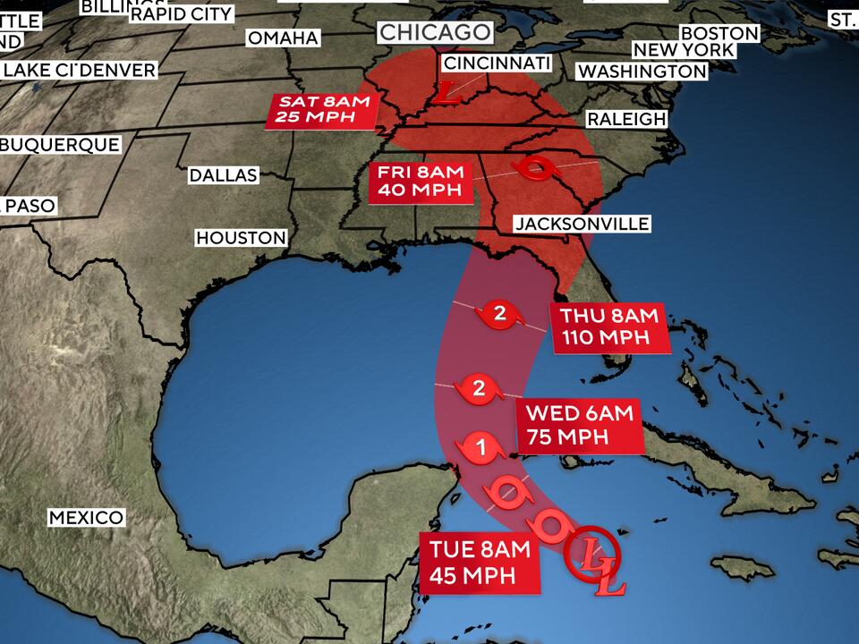
On Wednesday, Helene is expected to make its way toward the eastern Gulf Coast, moving over waters that are experiencing record warmth. This warm water serves as a significant fuel source for intensifying tropical storms.
According to Brian McNoldy, a senior research associate at the University of Miami’s Rosenstiel School of Marine, Atmospheric, and Earth Science, the ocean heat content in the Gulf of Mexico is currently at record levels. Warm water plays a crucial role in strengthening tropical systems.
Sea surface temperatures along Helene’s projected path are hovering around 89 degrees Fahrenheit, which is 2 to 4 degrees Fahrenheit above normal. These elevated temperatures are closely linked to climate change, as highlighted by Climate Central, indicating that the North Atlantic Ocean has absorbed 90% of the excess heat generated by greenhouse gas emissions in recent years.
In addition to the warm waters, the storm is expected to pass directly over the Loop Current, which is known for its exceptionally warm waters that flow from the Caribbean into the eastern Gulf of Mexico. The combination of warm water, high moisture levels, and low wind shear creates an environment conducive to storm intensification.
As Hurricane Helene approaches, there is strong confidence that it will be the third in a sequence of four U.S. hurricanes this year to undergo rapid intensification. A storm is considered to rapidly intensify if it increases its wind speed by at least 35 mph in just 24 hours.
Forecasts from the National Hurricane Center predict that Helene could achieve wind speeds of up to 80 mph by Thursday, swiftly transforming from a 30-mph tropical disturbance into a robust Category 2 hurricane with winds reaching 110 mph at landfall. Some high-resolution models even suggest a possibility of Helene becoming a major hurricane.
The National Hurricane Center projections indicate that the west coast of Florida is poised to feel the brunt of Hurricane Helene, with potential landfall locations ranging from Destin to Tampa. Residents in these areas are advised not to concentrate solely on the storm’s forecast track, as Helene is expected to be a large and fast-moving system. The impacts of the storm will extend considerably beyond its center, particularly on the eastern side where destructive storm surge flooding may occur.
Florida Governor Ron DeSantis has declared a state of emergency for 41 counties in anticipation of the storm’s approach. The shallow waters and unique geographical shape of the Gulf Coast make it especially vulnerable to storm surge flooding during hurricanes.
As the storm develops further and tracks toward the United States, storm surge watches and hurricane watches are likely to be issued for extensive areas along the Florida coastline.
Source: CBS News