Physical Address
304 North Cardinal St.
Dorchester Center, MA 02124
Physical Address
304 North Cardinal St.
Dorchester Center, MA 02124

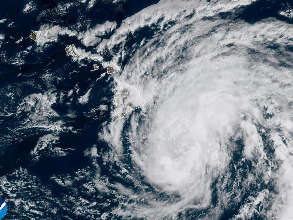
Hawaii is preparing for intense weather conditions as Tropical Storm Hone has been upgraded to a hurricane status. Wind gusts exceeding 85 mph are expected to impact the islands significantly.
On Sunday, Hawaii’s National Weather Service (NWS) announced the change, issuing warnings about strong winds and the ongoing risk of flash flooding. “Hurricane Hone is currently passing south of the Big Island,” said a spokesperson from the NWS. “The primary threats to the state involve the potential for heavy rainfall, damaging winds, and large surf along east-facing shores.”
In response, Governor Josh Green declared a state of emergency on Saturday, which is anticipated to last through Monday. This declaration enables the governor to mobilize the National Guard and utilize state disaster funds, while also suspending certain state laws that might impede a swift response to the emergency.
Wind speeds ranging between 50 and 75 mph are forecasted, with gusts potentially reaching up to 86 mph. However, according to the National Hurricane Center (NHC), despite the intensity of the winds, the hurricane is expected to gradually weaken starting Sunday afternoon.
Throughout Monday morning, tropical storm conditions are likely to persist on the Big Island, with peak winds expected to be strongest at higher terrains, across headlands, and through mountain passes.
Hurricane Hone is projected to deliver rainfall totals between 6 to 12 inches in targeted areas of the Big Island, with the possibility of even higher amounts in localized regions. The smaller islands could experience rainfall of about 2 to 4 inches.
Jon Jelsema, a senior forecaster with the Central Pacific Hurricane Center in Honolulu, explained, “As the rain gets pushed up the mountain terrain, it effectively wrings it out, similar to squeezing a wet towel.” He noted that this rainfall has already led to flooding issues.
“Roads have been cut off by high flood waters in the windward sections of the Big Island, which is currently the area most affected by flooding,” Jelsema added.
Due to the hazardous surf conditions, several beach parks on the Big Island were closed, and shelters were opened as a precautionary measure, according to Mayor Mitch Roth. A tropical storm warning remains in effect for Hawaii County, with warnings of life-threatening surf and rip currents across the island chain.
On Saturday, wave heights of 14 to 18 feet were anticipated along the Big Island’s east-facing coastline. The National Weather Service indicated that these waves could remain dangerously large and unpredictable into Sunday.
Maui’s eastern shores are also expected to face a rapid rise in wave heights. Residents have been advised to stay away from shorelines in the affected areas amid these warnings.
The situation brings back memories of the devastating wildfires in Maui, which occurred just over a year ago on August 8, 2023. Those wildfires, exacerbated by hurricane-force winds, became the deadliest US wildfire in over a century, claiming 102 lives. The dry, overgrown vegetation coupled with drought conditions significantly fueled the flames.
“They have to take this seriously,” stated Calvin Endo, a member of the Waianae Coast neighborhood board and a resident of Makaha, an area on leeward Oahu that is particularly susceptible to wildfires.
Source: AP News