Physical Address
304 North Cardinal St.
Dorchester Center, MA 02124
Physical Address
304 North Cardinal St.
Dorchester Center, MA 02124

A powerful storm brewing in the Caribbean Sea is expected to strengthen into a hurricane as it moves into the Gulf of Mexico over the coming days. Forecasts indicate it could make landfall along the Gulf Coast as early as Thursday, potentially as a significant Category 3 hurricane.
AccuWeather Lead Hurricane Expert Alex DaSilva emphasized the need for preparedness, stating that everyone in the Florida Panhandle and the Big Bend region should be ready for hurricane impacts. He noted that this system has the potential to become the strongest hurricane to make landfall in the U.S. this season.
According to meteorologist Jonathan Erdman from Weather.com, most forecast models predict that the hurricane will hit somewhere in Florida or the northern Gulf Coast on Thursday.
The weather system was elevated to “potential tropical cyclone nine” status on Monday morning. It will be officially named Helene once it develops into a tropical storm, which is expected either later on Monday or by Tuesday.
Unlike many hurricanes that typically take days or weeks to traverse the Atlantic, giving people time to prepare, this storm is anticipated to rapidly develop and intensify once it enters the Gulf of Mexico.
AccuWeather meteorologist Jon Porter urged residents along the Gulf Coast to start preparations now, without waiting for the storm to receive an official name. He pointed out the possibility that this storm could strengthen into a major hurricane, defined as a Category 3 on the Saffir-Simpson Hurricane Wind Scale, which features sustained winds ranging from 111 to 129 mph.
Porter suggested that this hurricane could be a defining event of the 2024 hurricane season.
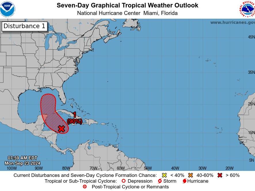
The National Hurricane Center reported that showers and thunderstorms are becoming more organized in connection with a broad area of low pressure over the northwestern Caribbean Sea. The Center stated, “Environmental conditions appear favorable for further development of this system.” They indicated that a tropical depression or storm is likely to form within the next day or two as the system continues its northward movement into the southeastern Gulf of Mexico, where conditions for further development are expected to improve.
Helene could emerge as a formidable hurricane in the Gulf, Erdman noted, as there is an abundance of deep, warm water in the northwestern Caribbean and parts of the Gulf of Mexico to fuel the storm. In fact, the Gulf of Mexico is currently experiencing record high levels of heat content for this time of year, as noted by tropical scientist Brian McNoldy from the University of Miami.
Sustained winds of at least 111 mph are projected, with powerful gusts reaching up to 120 mph anticipated in areas where the storm makes landfall on Thursday.
Rainfall of widespread amounts between 8 to 12 inches is likely, raising concerns of flooding. Rounds of rain could start arriving as early as late Tuesday afternoon or evening, initially affecting the Keys before shifting northward.
Power outages are expected across the Florida Panhandle and Big Bend region, with potential impacts extending into Georgia, Alabama, southern Tennessee, and parts of western South Carolina and North Carolina, as warned by AccuWeather.
As the storm approaches later this week, threats from storm surge and possible tornadoes will also arise, contributing to the hazards impacting the region.
Earlier this year, federal forecasters projected an “extraordinary” hurricane season, predicting the possibility of as many as 24 named storms. In comparison, an average season typically sees around 14 named storms based on weather data from 1991 to 2020.
Source: USA TODAY


