Physical Address
304 North Cardinal St.
Dorchester Center, MA 02124
Physical Address
304 North Cardinal St.
Dorchester Center, MA 02124

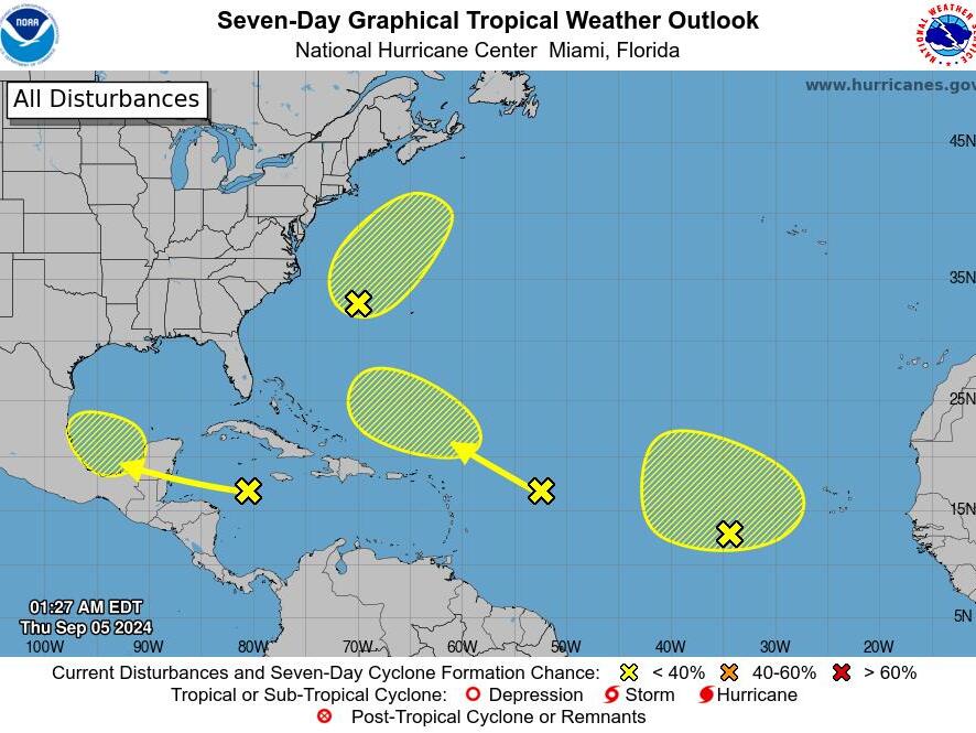
The National Hurricane Center is monitoring five tropical disturbances in the Atlantic Ocean, as reported in an advisory released early Thursday morning.
After a notable pause in hurricane activity over the past few weeks, the tropics appear to be awakening. There have been no named storm formations in the Atlantic since August 12, when Tropical Storm Ernesto formed. According to Phil Klotzbach, a hurricane forecaster at Colorado State University, this absence of storms during this period has occurred only once since 1966. That instance was in 1968, a year which resulted in only eight named storms overall.
“This pronounced quiet period is especially remarkable given that it coincides with the time of year where the Atlantic climatologically gets very busy,” Klotzbach noted in an online forecast update published on September 3.
The first disturbance monitored by the National Hurricane Center is generating widespread thunderstorms across the northwestern Gulf of Mexico, impacting regions near Louisiana and Texas. The Center announced that upper-level winds are expected to become less favorable for development as a frontal boundary approaches the system by Friday and Saturday. Despite the low likelihood of development, heavy rainfall is anticipated across sections of the northern Gulf Coast over the next day or so.
The National Weather Service in New Orleans has issued a Flood Watch for portions of southeast Louisiana and the Mississippi Gulf Coast, which remains in effect through Friday evening. Rainfall amounts could reach between three to five inches, with the potential for locally higher totals.
The second system being tracked is described as a non-tropical area of low pressure, located several hundred miles east of North Carolina. It is producing limited shower and thunderstorm activity and could develop some subtropical characteristics as it moves north-northeastward, remaining offshore from the northeastern U.S. coast. However, the NHC predicts that once this low crosses over cooler waters by late Saturday, further subtropical development is unlikely, estimating a 20 percent chance of formation over the next week.
The third wave is producing showers and thunderstorms in the eastern tropical Atlantic. This system is anticipated to develop slowly over the coming days as it progresses northward or northwestward, given a 20 percent chance of development in the following seven days.
The fourth system is moving rapidly westward at about 20 mph over the western Caribbean Sea and is creating a broad area of disorganized showers and thunderstorms. Possibilities for development could emerge a few days from now after the system passes the Yucatan Peninsula and enters the southwestern Gulf of Mexico, where it has a 30 percent chance of formation within the next week.
The last wave, located several hundred miles east of the Lesser Antilles, is expected to struggle with strong winds that may deter its development in the immediate future as it ships west-northwestward. However, conditions could become more favorable for gradual development by early next week as it moves over the southwestern Atlantic, with a 10 percent chance of formation in the next seven days.
Even as warm waters dominate the basin, the presence of dry air, Saharan desert dust, and disruptive winds have negatively impacted tropical development, as examined by AccuWeather. Alex DaSilva, a hurricane expert at AccuWeather, pointed out a cold pocket of water near the western coast of Africa, which is also interfering with the typical atmospheric conditions that allow storms to develop.
Interestingly, there have been more storms in the Pacific than in the Atlantic this year, contrary to the usual tendency. Some forecasting teams, including AccuWeather, have updated their predictions for the hurricane season, lowering anticipated storm formations from as many as 25 to a revised estimate of 16 to 20, which still exceeds the long-term average of 14 storms.
Looking ahead, Klotzbach’s team anticipates below-average activity in the upcoming weeks, as prevailing weather patterns continue to suppress storm formation. The Atlantic hurricane season will remain active until November 30.
Source: USA Today