Physical Address
304 North Cardinal St.
Dorchester Center, MA 02124
Physical Address
304 North Cardinal St.
Dorchester Center, MA 02124

Many towns in southeastern North Carolina faced record-breaking rainfall on Monday as a potential tropical cyclone swept through the region. Carolina Beach, located near Wilmington, experienced significant precipitation, with the National Weather Service reporting an astonishing 18 inches of rain at Ocean Boulevard over just 12 hours. Meteorologists suggested that such an extreme event occurs only “once every 1,000 years.”
“Historic rain has fallen across Carolina Beach, Southport, and BSL today,” the Wilmington weather service posted on social media on Monday afternoon. They noted that volunteer rain gauges recorded over a foot of rain since midnight.
According to data from the National Oceanic and Atmospheric Administration (NOAA), rainfall amounts exceeding 12 inches within a 12-hour window occur only once every 200 years, on average, in this region. Many areas reached this rare threshold, reporting excessive rainfall amounts from midnight through midday on Monday.
The staggering 18-inch total at Ocean Boulevard marked the highest recorded from this weather system. Nearby locations, including Snows Cut Bridge, Sunny Point Military Terminal, and Boiling Springs Lakes, also reported over 14 inches in just half a day. In addition to these totals, parts of Southport and St. James crossed the foot mark, while Leland, located closer to Wilmington, received nearly 7 inches. In contrast, Wilmington saw significantly lower rainfall, with the Wilmington Airport recording just over 3.5 inches.
The severe rainfall led to dangerous flash flooding and strong gusty winds throughout southeastern North Carolina on Monday. The National Hurricane Center issued warnings that the impacts of the storm, identified as Potential Tropical Cyclone Eight, could be “life-threatening.” They estimated that the turbulent system could add another 4 to 8 inches of rain before nightfall, with some areas potentially receiving up to 10 inches.
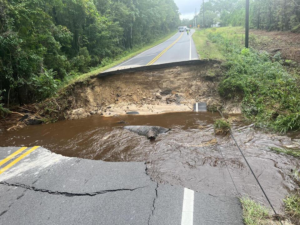
Images shared by the Wilmington weather service revealed the extent of damage and chaos caused by the deluge. In Brunswick County, part of the road collapsed into a pool of muddy water, showcasing the destructive power of the flooding.
“Major road washouts have occurred across Brunswick County due to today’s heavy rainfall and flash flooding,” the service informed the public.
Fortunately, forecasters indicated that the areas affected by the heavy rains on Monday would likely avoid additional rainfall on Tuesday. The flash flood warnings that had been issued across various zones were set to expire before midnight.
This unusual weather event served as a stark reminder of the intensity that tropical systems can bring, particularly as regions like southeastern North Carolina grapple with environmental challenges exacerbated by climate change. Communities remain on high alert, effectively assessing damages while preparing measures for upcoming weather challenges.
As recovery efforts begin, local authorities will be working swiftly to address the fallout from the storm and initiate road repairs where necessary. Awareness of weather patterns and proactive measures will be crucial for minimizing future risks for residents in these flood-prone areas.
Source: news organizations