Physical Address
304 North Cardinal St.
Dorchester Center, MA 02124
Physical Address
304 North Cardinal St.
Dorchester Center, MA 02124

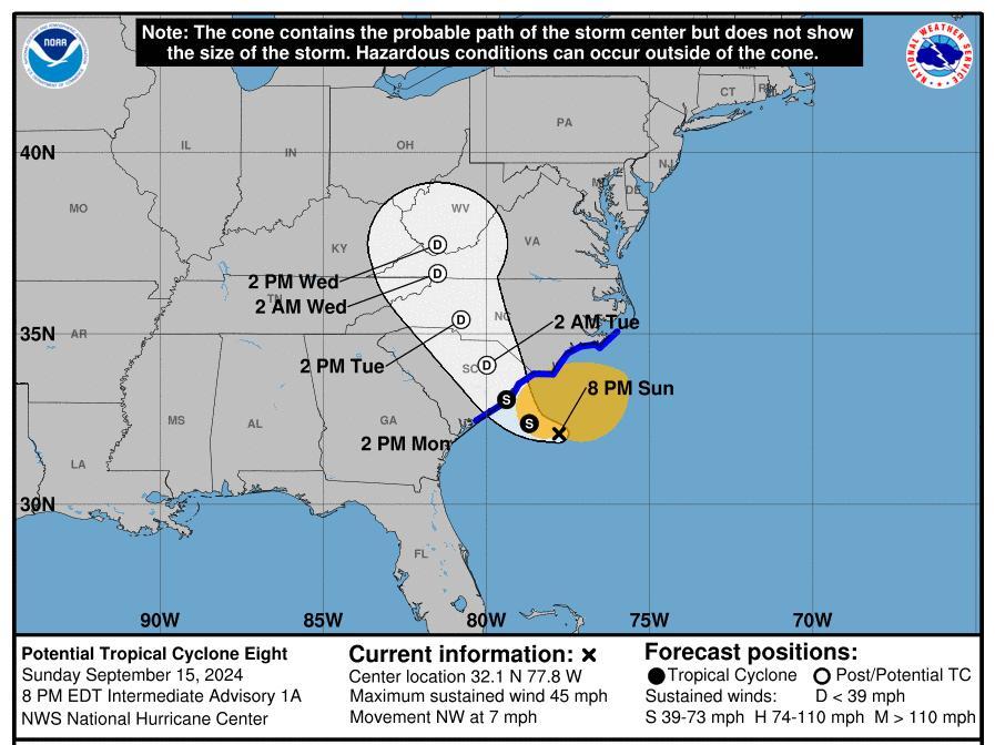
Residents of North and South Carolina are preparing for heavy winds, rain, and the risk of flooding and tornadoes as a potential tropical disturbance approaches the region. Known as Potential Tropical Storm Eight, this system is anticipated to make landfall on Monday afternoon.
As of Monday morning, the system was classified as a low-pressure area, not yet reaching tropical storm status, according to the National Hurricane Center. Traveling at 3 mph, the system was approximately 100 miles east of Charleston, South Carolina, with maximum sustained winds of 50 mph.
The storm is forecast to move across both states overnight and remain impactful into Wednesday. If it strengthens into a named tropical storm, it will be referred to as Helene; however, forecasters are now saying the likelihood of that has diminished due to an observed decrease in the storm’s organization.
A tropical storm warning has been issued for a significant portion of both states as of Monday morning. This warning indicates the expectation of gusty winds, heavy rainfall, and coastal flooding in the warned areas. Despite uncertainties regarding the storm’s classification, regions under warning could still experience winds strong enough to meet tropical storm criteria.
According to advisory details, the storm could unleash between 8 to 10 inches of rain in some areas, particularly those most vulnerable to rainfall. There is also the risk of tornadoes developing, particularly in the eastern portions of both states through Monday night.
Forecasters warn that rainfall may lead to considerable flash flooding and urban flooding across the Carolinas. The threat extends into the Mid-Atlantic region as well, where isolated flooding could occur. Rivers in southeastern North Carolina and northeastern South Carolina may experience minor flooding throughout Monday night.
The National Hurricane Center has indicated that the storm is unlikely to gain significant strength before landfall and will continue to weaken once it moves inland, with expectations for it to dissipate by Wednesday.
High tide conditions, amplified by the full moon, combined with large ocean swells and strong northeast winds, could lead to moderate coastal flooding early in the week. There is a chance for further storm development that could exacerbate flooding risks in coastal areas.
Although the storm’s maximum sustained winds exceed the 39 mph threshold needed for tropical storm classification, it remains too disorganized at this point. AccuWeather’s lead hurricane expert, Alex DaSilva, noted that a closed center of circulation needs to form for the system to qualify as a tropical storm, with current estimates placing that likelihood at around 70%.
Regardless of whether it formally becomes a tropical storm, the potential impacts will be similar, including the possibility of hazardous flash floods driven by heavy rain extending from the Southeast to the Mid-Atlantic region.
The Carolinas could experience winds reaching up to 60 mph, leading to localized power outages and fallen trees. Tornado activity could also occur overnight, as these conditions can develop rapidly and pose significant danger.
In addition to other impacts, beach erosion is a concern. The coastline, already vulnerable due to previous storms, could face further complications from the approaching system.
Due to the anticipated conditions, some schools in North Carolina have opted not to open. Brunswick County Schools announced on social media that students should stay home, providing optional work for teachers. Brunswick Community College closed for the day, offering remote classes where feasible.
However, schools in New Hanover and Pender counties will continue with a regular schedule.
Rip currents, which can be particularly dangerous for swimmers, are also a concern along the Outer Banks. While the risk of strong rip currents was higher around low tide, the weather service continues to advise against swimming due to the dangers posed by such currents.
“Rip currents can sweep even proficient swimmers away from shore,” the update cautioned, adding that they can cause serious injuries including neck and back damage due to rough shore breaks.
As conditions develop, residents are urged to remain vigilant and prepared for potential severe weather impacts.
Source: USA TODAY