Physical Address
304 North Cardinal St.
Dorchester Center, MA 02124
Physical Address
304 North Cardinal St.
Dorchester Center, MA 02124

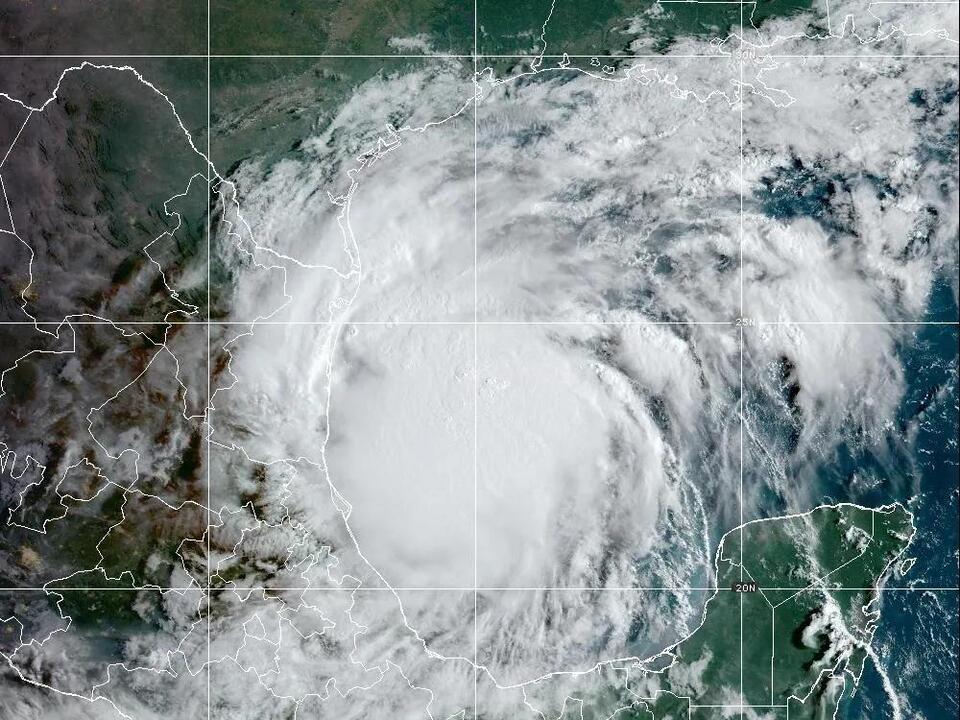
Tropical Storm Francine emerged in the Gulf of Mexico on Monday and is forecast to potentially become a low-end Category 1 hurricane by Wednesday. It is anticipated to make landfall on the Upper Texas or southwestern Louisiana coasts.
Authorities, including AccuWeather, are warning that heavy rainfall and strong winds from the storm could result in downed trees, power outages, and damage to structures, impacting areas from northeastern Mexico to the southern United States.
As a precaution, a hurricane watch was issued for parts of the Louisiana coast, indicating that people in the area should prepare for possible hurricane conditions within the next 48 hours.
Additionally, a tropical storm watch is in effect for southern Texas, specifically from Port Mansfield to the Rio Grande River, suggesting that tropical storm winds could reach the area by Tuesday evening. A similar tropical storm watch applies southward along the Mexican coast down to Barra del Tordo.
According to reports, the center of the storm was situated around 245 miles south-southeast of the mouth of the Rio Grande and approximately 480 miles south of Cameron, Louisiana, as of Monday morning. The storm has sustained winds of about 50 mph and is moving very slowly at just 5 mph in a north-northwest direction.
Francine marks the sixth named storm in the 2024 Atlantic hurricane season, following Ernesto, which dissipated on August 20.
The National Hurricane Center is currently monitoring three systems, with another system in the central tropical Atlantic showing a 60% chance of developing into a tropical storm within the next 48 hours. A further storm located to the east also shares a 60% chance of development over the coming week.
Forecasts suggest that Francine could develop into a low-end Category 1 hurricane by Wednesday, with winds reaching up to 85 mph. The storm may deliver between 4 to 8 inches of rain along the coastal areas, with localities in northeastern Mexico and the Texas and Louisiana coasts facing the risk of receiving up to 12 inches of rain by Thursday, raising concerns over potential flash flooding.
The system is expected to move more quickly to the northeast by late Tuesday, encountering a cold front along the Gulf Coast. This movement positions Francine just off the Texas coast, aiming for possible landfall in either upper Texas or Louisiana by Wednesday, according to Donald Jones, a meteorologist associated with the National Weather Service in Lake Charles, Louisiana.
Coastal regions of Vermilion, Iberia, St. Martin, and St. Mary parishes have the highest likelihood of experiencing tropical storm-force winds, estimated at 70-80% chance. Hurricane watches are currently in place along the Louisiana coast, covering the eastern part of Cameron Parish and extending eastward along the central coast of Louisiana.
Jones advised that it is always wise to prepare for one category higher than what is forecasted. He indicated that there is a possibility Francine could escalate to maximum strength right before landfall and then stop intensifying upon interacting with the cold front.
A storm surge watch has been issued for regions west of Sea Rim State Park in southeast Texas extending to Morgan City, Louisiana, with storm surges potentially exceeding three feet. Jones estimates peak storm surge heights could reach between 5 to 10 feet from Cameron, Louisiana through Port Fourchon, with surf heights of 4 to 7 feet likely along Louisiana’s southern coast.
Residents in southwestern Louisiana are being urged to closely monitor the weather, with forecasts indicating there’s a possibility that the storm could strengthen into a Category 2 hurricane. Current water temperatures in the Gulf are above average, conducive to further hurricane development.
Despite potential strengthening due to warm waters and moisture, the system may face challenges from increasing wind shear and drier air which could restrict substantial intensification.
Jones projected that regions south of Interstate 10 in southwestern Louisiana could see 8 to 12 inches of rainfall, emphasizing that flooding poses a significant threat. The track of the tropical storm has shifted slightly eastward and may continue that trend.
Source: USA Today