Physical Address
304 North Cardinal St.
Dorchester Center, MA 02124
Physical Address
304 North Cardinal St.
Dorchester Center, MA 02124

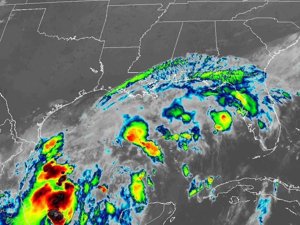
A potential tropical storm developing in the Gulf of Mexico has the potential to reach low-end Category 1 hurricane status by Wednesday, with forecasts indicating a possible landfall along the Upper Texas or southwestern Louisiana coasts.
After a period of calm in the tropics, the National Hurricane Center reported a 90% chance of storm formation within 48 hours in a Sunday night update. This marked a notable shift in the tropical activity in the region.
A tropical storm watch has been issued for Southern Texas, stretching from Port Mansfield down to the Rio Grande River. This advisory indicates that winds associated with a tropical storm may start impacting the area by Tuesday evening. Additionally, a tropical storm watch is in effect for the region of the Mexican coast leading to Barra del Tordo.
As of Sunday night, the center of the developing system was approximately 320 miles south-southeast of the Rio Grande’s mouth and about 550 miles south of Cameron, Louisiana. The system was moving at a sluggish pace of just 5 mph north-northwest, while sustained winds were estimated to be around 50 mph.
The hurricane center expects the system to develop into a tropical storm by Monday, bringing potential tropical storm conditions to the northeastern Mexican coast and the southern tip of Texas.
Unless existing systems in the tropical Atlantic develop first, this storm would be named Francine, marking it as the sixth named storm of the 2024 hurricane season. By Monday, the upper Texas and Louisiana coasts may experience hurricane, storm surge, and tropical storm watches.
Officially designated as Potential Tropical Cyclone Six, this system is among three that the hurricane center is currently monitoring. Another system, located in the central tropical Atlantic, has a 60% chance of becoming a tropical storm within 48 hours, while a third system to the east shows a 50% chance of development within the next week.
The current forecast predicts that the storm could escalate to a low-end Category 1 hurricane by Wednesday, with maximum sustained winds of approximately 80 mph. The hurricane center anticipates that coastal areas could see rainfall amounts ranging from 4 to 8 inches, with some regions in northeastern Mexico and along the Texas and Louisiana coasts experiencing up to 12 inches of rain through Thursday, creating a risk for flash flooding.
Forecast models suggest the Gulf system will gain speed by late Tuesday as it interacts with a cold front along the Gulf coast. This trajectory implies that the storm will be positioned just offshore Texas while heading toward a potential landfall on the upper Texas or Louisiana coast by Wednesday evening, according to meteorologist Donald Jones from the National Weather Service’s Lake Charles, Louisiana office.
Jones recommended that residents in southwestern Louisiana monitor the situation closely, as there is a possibility that the storm could develop into a Category 2 hurricane. Current models indicate a landfall projected for Wednesday evening along the southwestern Louisiana coast.
Water temperatures in the Gulf are reported to be warmer than usual, which could facilitate further hurricane development. However, the hurricane center also noted the possibility of higher wind shear and slightly drier air conditions that could temper strengthening as the system forms a clearer center.
Jones emphasized the concern of flooding, stating, “We’re looking at 8 to 12 inches of rainfall south of Interstate 10 in southwestern Louisiana.” The storm’s predicted track has already adjusted slightly eastward and could shift further in that direction.
As preparations begin along the Gulf coast, officials and residents are urged to remain vigilant and stay informed as the situation develops.
Source: USA Today