Physical Address
304 North Cardinal St.
Dorchester Center, MA 02124
Physical Address
304 North Cardinal St.
Dorchester Center, MA 02124

Hurricane Francine made landfall Wednesday afternoon in southern Louisiana, specifically in the Parish of Terrebonne, located roughly 30 miles south-southwest of Morgan City. At landfall, the storm was classified as a Category 2 hurricane, with maximum sustained winds estimated at around 100 mph, according to the National Hurricane Center.
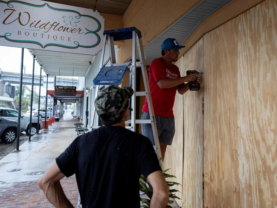
Residents of Louisiana were well-prepared for the storm’s arrival, having anticipated its escalation into a dangerous Category 2 hurricane. Francine is a life-threatening storm, with predictions indicating potential rainfall of up to a foot, damaging winds, and storm surges reaching 10 feet in various locales.
As of 5 p.m. ET on Wednesday, winds associated with the northern eyewall of Francine were sweeping across southern Louisiana’s coastline. The National Hurricane Center issued urgent advisories, stating, “Now is the time to stay inside and away from windows.” They recommended residents have multiple means for receiving updates and warnings as conditions worsened.
With sustained winds hitting 100 mph, the storm was forecasted to continue impacting the central Louisiana coast into the evening. The hurricane center warned that “life-threatening storm surge and hurricane-force winds” were imminent.
By Wednesday afternoon, reports of power outages along the Louisiana coast began to increase, with over 9,000 outages logged according to various trackers. In response to the storm, Louisiana Governor Jeff Landry mobilized the National Guard, deploying almost 400 high-water vehicles, along with 87 boats and 50 helicopters to facilitate rescue and recovery operations. He urged citizens to heed the advice of local officials, including evacuation orders when issued.
Fortunately, a glimmer of optimism emerged as the hurricane center projected Francine to weaken considerably following landfall. The storm is expected to move into Mississippi and subsequently toward the Mississippi Valley, eventually being downgraded to a tropical depression by the time it reaches Memphis on Thursday night.
In terms of developments, President Joe Biden approved an emergency declaration for Louisiana shortly before the storm made landfall. This declaration aims to assist in response and disaster relief efforts motivated by state officials’ requests.
In Texas, Governor Greg Abbott emphasized the high risk of life-threatening storm surges, encouraging residents along the Gulf Coast to follow local guidance, including potential evacuations. Joe Rua, a meteorologist with the weather service in Lake Charles, noted that the northern and northwestern sectors of Francine’s eyewall were rotating into southern St. Mary Parish, with sustained winds on Eugene Island exceeding 77 mph and gusts reaching up to 88 mph by early afternoon.
In Morgan City, where the storm was projected to make landfall, local police implemented a curfew from 11 a.m. Wednesday to 6 a.m. Thursday. Residents were advised to shelter in place. Trenton Ho, a local resident, expressed a sense of calm despite Francine’s approach, saying, “I’m not the least bit concerned about this storm,” citing his experience living in the area.
Even as Francine maintains its trajectory, the threat of tornadoes arises as it moves inland. Tornado risks on Wednesday were forecasted for southeastern Louisiana, southern Mississippi, and southern Alabama, with expectations that this risk would expand into Thursday.
Forecasters have cautioned that dry air mixing within Francine’s circulation could lead to increased severe thunderstorms, raising the potential for tornado activity. Major population centers such as Mobile, Birmingham, Montgomery, and Huntsville in Alabama, along with Tallahassee, Florida, and Tupelo, Mississippi, could be under threat, made worse by heavy rainfall that may obscure tornado formations.
The hurricane center indicated that strengthening was likely leading up to the storm’s arrival. While some forecasts showed Francine reaching Category 2 strength, factors like increased wind shear and dry air suggest that it may not sustain this intensity at landfall, although serious risks will remain post-impact along Louisiana’s coast.
The storm’s influence could persist into Thursday morning, delivering coastal flooding, high winds, and heavy downpours, as well as potential tornado activity. The National Weather Service in New Orleans cautioned that areas near and west of the Pearl River should prepare for damaging winds, while lower bayou regions could face hurricane-force winds. Additional concerns include power outages and damage to infrastructure, such as trees and roofs.
Mandatory and voluntary evacuations were already under way in various Louisiana parishes, while shelters were opened in Terrebonne Parish. Oil and gas companies in the Gulf of Mexico began shutting down production in advance of the storm, with significant reductions reported, impacting daily oil and gas outputs in the region.
As Francine prepares to make its mark, residents are reminded to take extra caution, stay updated on evacuations, and heed local officials’ guidance for the safety of themselves and their families.
Source: USA Today